
Ancona Local Impact Assessment: Ancona early warning system

THE LANDSLIDE EVENT
A large and deep landslide interested on 13th December 1982 the northern area of the Ancona city, the “Montagnolo” hill started to slide towards the sea (Figure 1).
The event involved, about 180 millions of cubic meters of soil and rock; it damaged private houses and strategic buildings and infrastructures, about 3000 people were evacuated. The railway and the main road were blocked, the gas and water supplies were interrupted.
TIPOLOGY
Taking into account all the researches and investigations during the last 25 years both in site and in laboratory, we can conclude that the Great Landslide of Ancona city is an Deep-seated landslide (complex, composite according to Cruden & Varnes 1996) reactivated after a long period of precipitation; new fractures were opened by a long period of earthquakes 10y before (6 months duration).
The landslide involves clay and silty clay layers (Pliocene-Pleistocene), fractured with different OCR
parameter, alternated with thin sand levels.
Overlapped sliding zones are active (maximum depth: 100-120 m, maximum depth 1982 event is 75 m bgl).
Across all the body of the landslide, in horizontal direction, parallel to the coast, there are two natural trenches that cross the slope. These trenches are upstream of old landslides slid down and now they are filled with heterogenic and plastic soils. These soils involves clay and silty clay, mud and thin sand level with some fragments of calcarenitic layers.
These trenches together with a complex structural system of fracture and discontinuity, influenced the system of underground water.
All the geological and geotechnical analyses of the landslide mechanisms aimed at the consolidation preliminary design in the 2000; but this plan concluded that a consolidation was impossible, both due to very large expenses and to a very strong environmental impact, which would have totally changed the site appearance with a severe socio-economical impact.
Ancona Administration decided then to live with the landslide reducing nevertheless the risk for the people living there.
EARLY WARNING SYSTEM
In 2002 the Regione Marche, promulgated a law specifically for the people living in the landslide, to give Ancona Administration the responsibility of creating an Early Warning System and an Emergency Plan for people. The whole project has the aim both to issue to the population a certification to live safely in their homes and to check the landslide moving.
It is already installed a monitoring system based on 7 total stations, 33 geodetic GPS, 3 DMS multiparametric columns installed down to 95 m depth.
Surface monitoring The surface monitoring system is based on:
- 7 Automatic Robotic Stations (of high precision)
- 230 reflector points (installed partly on the 64 inhabited houses and on the structures and infrastructures)
- 26 geodetic GPS (Global Position System - at single frequency L1 (installed on the 64 inhabited houses)
- 8 geodetic GPS at dual frequency L1+L2 (reference)
- 7 high precision clinometric sensors for the stability control of the main stations of the I and II level of the net (automatic geodetic boxes).
The combination of the different instruments: GPS, Automatic Robotic Stations and the clinometric sensors allows us to monitor in the 3D (3D, X, Y, Z) a great number of points previously identified, to keep them under supervision with different measuring technical and from different control positions. This monitoring system is studied to try to determine every surface movement both in the area and in the inhabited houses and to produce some alarms managed by a Control Centre H24 placed in the Town Hall, where a staff of technicians have to estimate the alarms. Only whenever the situation requires the Coordinator starts the Civil Protection Plain.
The measuring cycle is set up on 30 minutes, but in emergency or after a long rainy period, the system can operate in Real Time (Figure 2).
Figure 2 - Surface and in place borehole systems
The surface monitoring is based on GPS system in 3 different active levels, on 7 Automatic Robotic Stations and a later control with 7 high precision clinometric sensors for the stability control of the main stations of the I and II level of the net:
A - GPS system:
- Main Network (I level active at the moment) formed by n°3 main stations outside of the landslide area with n°3 geodetic GPS at dual frequency L1+L2 (reference) placed on two steady buildings, and a third one placed on a Geodetic box at Marina Dorica founded with a reinforced concrete pole (18 m).
- Secondary Network (II level active at the moment), formed by n°5 main stations inside of the landslide area with n°5 geodetic GPS at dual frequency L1+L2 (reference) placed on one building and on n°4 Geodetic boxes founded with reiforced concrete poles (12-18 m). All these geodetic GPS (n°3+n°5) form a high precision net working in the Early-warning system, on different control levels, to assure the GPS net (at single frequency L1), installed on 26 inhabited houses, a strong network; so that after an alarm it can work in real time RTK.
- Third Network (III level active at the moment) formed by n°26 geodetic GPS at single frequency L1 installed on 26 inhabited houses inside of the landslide area.
B - Automatic Robotic Stations
The Automatic Robotic Stations (n°7 of high precision) are placed in the I and II level networks, in the same places of the geodetic GPS at dual frequency L1+L2, except for the “Collodi school” building. They control (angles and distances) of 230 reflector spots placed on the inhabited buildings left and on the consolidation structures built inside the landslide.
Geotechnical monitoring (DMS)
The in place Geotechnical Monitoring System DMS (patents and trade mark CSG srl -Italy) was installed in February 2009. It is maden by n°3 Modular Dynamic System columns positioned inside borehole 100 m depth.
Each column is formed by n°85 Biaxial Inclinometric modules (range +/-20°, resolution 0,01°), n° 2 Piezometric Sensors (range 100 psi, resolution 0,01 m), n°85 Temperature Sensors (range 0-70°C, resolution 0,1°C) for a total active length of 85 metres with instruments, while the first ten metres and the last five ones are without any instruments. Digital compasses are also on board.
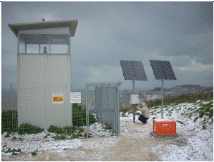
DMS columns have been preassembled and installed in site (Figure 3) with DMS REELER, connecting the required number of modules, each containing one or more geotechnical-geophysical sensors and the electronic boards for data collection and transmission.
The modules are linked by special 2D/3D flexible joints that allow strong, continuous adaptability to bends and twists of the borehole, whilst maintaining rigorously the orientation with respect to a reference system defined during installation.
DMS Early warning management
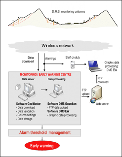
The data from the DMS instrumentation column are sent through RS485 protocol to the control unit, which compares them with threshold values (set by the user) and storages them in a circular buffer.
In case of movements larger than threshold values, the control unit sends a warning SMS/direct call to the staff on duty of the monitoring centre.
The same is the case of rapid change of water-table levels. Warning levels are counted from 1 to 4, in a growing order of danger.
In the monitoring centre, the control software GeoMaster takes care of downloading the data stored in the control unit memory buffer.
The DMS Early Warning is the software that visualizes the subsurface data at the monitoring centre and wherever an Internet connection is possible. The software in a compact check panel allows the contextual control of displacement (E-W, N-S, Module diagrams, on Polar and Azimuthal plots) as well as the variations of the level of the water table and temperature; time history of each multiparametric module, and displacement-velocity are also displayed at selected intervals.
Mr. Stefano Cardellini - Geologic Department, Ancona Municipality
Other news from the partners
With the contribution of the LIFE financial instrument of the European Community